Loggerheads, Moel Famau and Foel Fenlli
- daveatkinnerton
- Dec 8, 2024
- 10 min read
Updated: Jan 11, 2025
Walk: From Loggerheads to Llanferres via Moel Famau and Foel Fenlli in the Clwydian Hills
Distance: About 8 miles
Parking: Layby on A494 Mold to Ruthin road, in Llanferres, about 1km past the Druid Inn, heading away from Mold
Bus Route: T8 TrawsCymru service from Corwen to Chester
I'm almost reluctant to post this walk as, at the moment, the vast majority of it you get to yourself. As a BusPassNBoots walk, it is genius. About 5 minutes on a bus and 5 hours to walk back over two of the iconic summits of the Clwydian Hills. So when it goes viral :) leading to queues of people at the bus stop, I'll be devastated! I have done this walk in all seasons. I think winter was my favourite - I suspect it was Rosie's (Spaniel/ Swamp Hound) favourite too. Though mostly based on an outing in February 2024, I have borrowed some photos from other times, so I apologise if it looks like four seasons in a day (which isn't actually that rare in this part of Wales anyway).

Our walk starts at the free parking on the Layby opposite the small lane/track called the 'The Nant' (on which we'll return on our way back to the car). The layby is on the A494 Mold to Ruthin Road, on the left about 1km past The Druid Inn in Llanferres as you head away from Mold.
It's the bus stop on the opposite (Chester-bound) side of this busy road you want. The T8 TrawsCymru service is quite a busy little bus travelling between Corwen and Chester via Ruthin and Mold. It passes here approximately every hour. As we are only going literally a couple of stops, it is no hardship standing if the bus is very busy. Press the button as you pass the petrol station on the left hand side heading into Loggerheads. There is a popular country park here which, not for the first time, became a country lake in the atrociously wet weather we had in October this year (2024). There is also a very nice pub (old 17th century coaching inn) after which Loggerheads was named. It wasn't that long ago (1920s?) that someone reckoned that the sign outside the pub had the style of a famous artist (Richard Wilson) who had lived nearby in the 1700s, and was worth a small fortune. Before you don a stocking and head for the step ladders, the present stylised sign is new, to save people nicking the iconic painted one probably. Also, the painted one, the one taken indoors in the 1920s at least, whilst being a classy sign, has been deemed to not be the Richard Wilson masterpiece it was once thought to be, just a later quite good reproduction.
The pub's actual name is We three Loggerheads - yet there are only two heads on the sign (original and new). Cleverly, the third head is that of the viewer. I know what you are thinking: If humans had two heads, it would have had to be called We four Loggerheads. Actually, thinking it through, it would have to be We six Loggerheads wouldn't it. Anyway, more important than these sort of fine-art musings, the pub is lovely. And it does breakfast!

Once off the bus, enter the country park by whichever entrance is open and access the buildings which include a Café and free public loos. With these on your left, head toward the limestone cliffs, crossing over the River Alyn using the stone bridge to access the Leete path. Turn left along the Leete with the limestone escarpment on your right and the river on your left. A there and back again on this path is a day out for some people, but not for us today!

The Leete describes the feature dug out of this hillside to carry water from the river upstream of the bridge you've just crossed to other mine workings at Rhydymwyn, approximately 3.5 miles downstream. The Leete was a pretty massive undertaking back in the day, found necessary as, in dry weather, the river from this point on, regularly disappears underground leaving nothing useful to drive the machinery etc at the other end. I was once told that the Leete (the dip/channel on the right of the photo) was used to transport the lead ore once mined here back to be processed at Loggerheads on small barges pulled by ponies. Disappointingly, this isn't true, it was just a clay-lined channel carrying water away from Loggerheads.

Follow the Leete path for a mile, looking out for a footpath finger-post indicating left (you can see the fingerpost just this side of Rosie (the dog) in this photo). If you come to a vertigo-inducing bridge spanning a deep cleft (The Devil's Gorge), you've gone a few hundred metres too far!
Follow the indicated path down to the river and cross it on a metal bridge. Make your way up the field on the other side of the valley to a gate accessing the footpath to the left of the track that leads from the property on the right. Follow this for a short distance. Cross over the drive of the property to the right and through another gate straight ahead to access a very claggy (clayey/ slippery) uphill path. This leads to another gate and short path, alongside the garden of a property to the left, which eventually tips you out on the main Loggerheads to Cilcain lane. Turn left and then immediately right uphill up a tarmacked dead-end lane.
After a few hundred metres, a small lane cuts in from the right (that will also get you to the top of Moel Famau). Ignore it, carrying straight on on the original lane until you come to a fork, the left branch of which is a drive to a private house.

Carry straight on here, a short way, to a metal gate. By this point the road has become a track. Cross a shallow stream and continue straight on slightly uphill, keeping to the track as it contours left with Coed Moel Famau (forest) directly ahead. Just as you are about to enter the forest, there is another metal gate and, immediately past it, a wooden stile on the right (see photo). This is start of our ascent up Moel Famau.
Warning: the stile isn't dog friendly so, if you are doing it with a short legged friend, human or animal, be prepared to man (or woman) handle them over.
The path to the top, though consistently steep, is obvious and lovely. You climb quicky crossing directly over a fire road to pick up the path again climbing steeply through the woods.
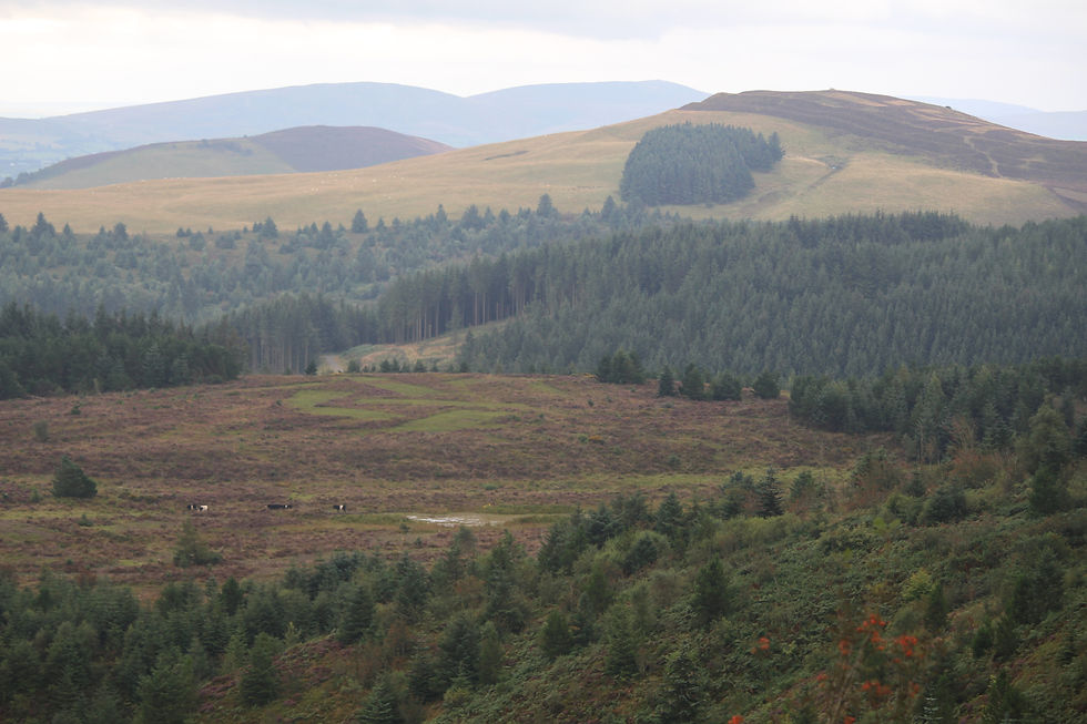
You will soon be able to look down (south) over the forest and out toward the ramparted Foel Fenlli (see photo) and backwards (east) over Flintshire and Cheshire. I love this bit. Moel Famau is a very accessible mountain and much visited. Very few people use this way up though, so it comes as a bit of a shock when you come out of the trees and climb the last steep bit and over a small (dog friendly this time) stile to access the busy summit plateau.

Although it looks pleasantly like a castle, the structure at the top is actually the base of a tower that was meant to look like an Egyptian temple. Construction started in 1810. I'm writing this whilst yet another named storm (the 4th of the 2024 season - I know this as it starts with a D) is giving North Wales a right royal battering, so can well imagine the conditions that, in October 1862, led to the eventual felling of the abandoned (and somewhat substandard), cut-price Grand Design (they ran out of money, just like many of the Grand Designs on the telly now do). What was left was the robust base providing a decent place to have your butties. Moel Famau is the highest peak of the Clwydian hills and the views are fab.

On a clear day, Eryri (Snowdonia) is clearly visible across the vale of Clwyd. There always seems to be something going on. The hot air balloon heading south down the Vale of Clwyd in December 2023 was my photographic favourite.

The path we want is the largest obvious track heading south (to the right hand side of the forested area (see photo)) down to the car park at Bwlch Penbarras. This next bit is a section of the Offas Dyke long distance path and is the most popular way up Moel Famau. Follow the acorn signs and the people until you arrive at the bwlch (pass) and car parking area.
The next summit on the walk is that directly opposite, the second highest peak in the Clwydian range - Foel Fenlli. It's a steep climb but made less painful by following the Offas Dyke route which takes a less direct route than the intimidating 'straight-up' one.

With your back to Moel Famau, leave the car park and the people behind following the acorn signs as they take you firstly direct up, then right, climbing around to the west flank. The path continues to climb, corkscrewing up to meet the ramparts of this once-magnificent hillfort and through its ancient entrance.
Rosie the spaniel and I love a good hillfort, and this is an excellent hillfort, with, not one, but an impressive two concentric ditches excavated out to make ramparts (or earthen banks at least). The innermost ditch would have been fenced on the inside and within the fence, spanning the summit area, there would have been wooden structures providing the amenities for whatever the hillfort was meant to do and accommodation for those doing whatever they were doing. Here, like many of the hillforts in this area, acid soil has left no remnants of anything organic. From evidence elsewhere however, it was discovered that at east some of the structures were built on raised platforms, slightly off-ground, giving yet another teasing snippet as to their purpose.
Digression Alert: I went to a lecture about Clwydian hillforts given the enthusiastic expert Dr Erin Lloyd Jones. It was great. The best part was that there are still no definitive answers as to what they were used for, just clues. Love that! The effort that went into making them implied community, or slaves (for which neck manacles of the period provide evidence) or both. It would have taken a lot of people a lot of time and they wouldn't be going to this sort of effort in these sort of places without some form of common motivation. I suspect the community had quite a bit of skin in the game. The 'Hill Fort' positions are prominent, defensive and close to routes that people would use to get from A to B - High Streets if you wish. Looking at the weather outside right now, you wouldn't want to choose this as a place to live permanently. Farmland would have been on the lower areas surrounding these forts, not within them. Archaeological evidence indicates occupation over hundreds of years (but not necessarily continuous). It is likely that, over these sorts of timeframes, the use will have been adapted by the changing circumstances (such as the arrival of those blokes with a decent suntan and the confident air of being able to build decent straight roads) so there are likely to be several answers to the puzzle of what hillforts were used for.

One interesting adaptation was the addition of hidden 'guard chambers' built just inside the entrances. So what do you reckon? I'm voting that they were High Street Banks. Big and prominent, accessible by trafficked routes yet not easy to get in and guarded with lethal force. Although Roman coins were found during excavations at Foel Fenlli (as well as Roman pottery, indicating occupation during or shortly after that era), I reckon the original wealth was grain and such like. Kept dry, and safe from neighbouring ruffians who would rather just knock some other community's farmers on the head and nick their stuff rather than go to the effort of farming their own. That's not what was offered as the answer to the question of what they were used for during the lecture by the way, just what I left thinking. End of Digression.

The previous photo (with Rosie by a finger-post) shows the path (still the Offa's Dyke path) as it cuts through the outer rampart. The Offa's Dyke signposting indicates right following the ramparts in a southerly direction and thus circumventing the summit. This is a shame. Unless the weather is unkind or you are carrying a humungous load, the summit is too great to be missed - over 500m high, massive cairn and fantastic 360 degree views. So, rather than go right as indicated by the finger post, go left to follow the upper rampart first north then east instead (see this photo). The route to the summit becomes obvious as the ramparts climb high above Bwlch Penbarras.

After taking in the views at the impressive summit cairn, west to Eryri and north back the way we've come, it's time now to turn the attention south where, weather permitting, the final leg of the trip is clear to see.
Our route drops down steeply off the summit, directly south, away from Bwlch Penbarras. The path, which now re-joins the Offa's Dyke path as it contours in from the west, heads for a stile, just to the right of the stand of trees you can see in the near foreground on the following photograph.

After the trees, the path turns left across the pasture land (superb in snowy weather - even if you just access it directly from the layby in which we parked for this walk. See the photo used as the walk thumbnail, taken in the snow in November 2024 ).
After the first pasture, Offa's Dyke path signs guide you downhill across another pasture (with conifers on your left) until, at the bottom, alongside a stream, the Offa's Dyke path acorns point right (west) toward Llandegla. At this point we say farewell to King Offa and his amazing technicolour path and head left (east) through a gate with the stream and forested area tumbling off to the right. The path goes across the top of a field with a stone wall to the left to join the track feeding the farm up above you. The track descends through the Nant (Valley in Welsh) eventually reaching an entrance to a farm and, just further on, a few small dwellings hugging the slope on the right hand side. This is the same 'Nant' opposite which is the layby and the car. Shortly after passing the dwellings you reach the main road, just 10m away from where you got on the bus. Genius. Enjoy!


Comments